
Blog Post
Insight: What’s New in Utah’s Census 2020 Geography?

By Natalie Young
Note: The opinions expressed are those of the author alone and do not reflect an institutional position of the Gardner Institute. We hope the opinions shared contribute to the marketplace of ideas and help people as they formulate their own INFORMED DECISIONS™.
Mar 26, 2021 – Last month, we blogged about the Census Bureau’s release of census 2020 geographic boundary data. Today we release “What’s New in Utah’s Census 2020 Geography?,” a fact sheet discussing geographic changes in greater depth. To our knowledge, this is the very first analysis of Utah’s census geography for any decennial census. For those who are new to census geographies or want a review, this fact sheet also includes a primer on census tracts, blocks, etc.
Some key geographic changes from census 2010 to census 2020 include:
- Utah has 11 newly incorporated places.
- Seven of the new incorporations were in Salt Lake County:
- Brighton (town)
- Millcreek (city)
- Five metro townships: Copperton, Emigration Canyon, Kearns, Magna, and White City
- Millcreek and the townships each incorporated in 2016, while Brighton incorporated in 2019.
- The four other new incorporations all became towns:
- Dutch John (Daggett County, 2015)
- Interlaken (Wasatch County, 2015)
- Cedar Highlands (Iron County, 2017)
- Bluff (San Juan County, 2018)
- Utah has five new census-designated places (CDPs), which are unincorporated areas: East Basin (Summit County), Hobble Creek and Sundance (Utah County), Lapoint (Uintah County), and Modena (Iron County).
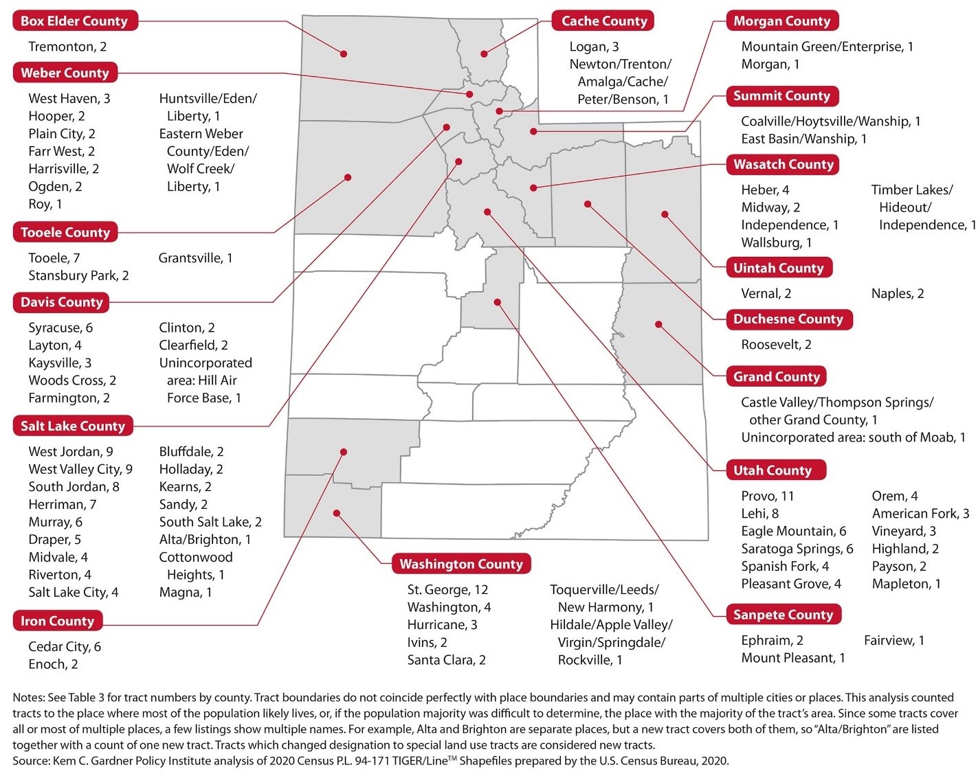
- 235 new census tracts were formed across the state, replacing 107 tracts from census 2010 (a net increase of 128 more tracts this decade).
- St. George and Provo led the way with 12 and 11 new tracts. Other places with high numbers of new tracts were West Jordan, West Valley City, South Jordan, Lehi, Herriman, and Tooele. Each gained seven to nine new tracts. See Figure 1 below for updates across the state.
Figure 1: New Census Tracts by Place, Census 2020 Geographic Products
Geographic information system (GIS) shapefile format boundary files and other geographic support products are available for public download as part of the 2020 census P.L. 94-171 redistricting data and the 2020 set of TIGER/Line shapefiles. The redistricting shapefile set includes the most frequently used census geographies within states. It also offers several 2010 boundaries alongside 2020 boundaries to simplify comparisons. The fact sheet lists all available state and county-level redistricting shapefiles for Utah. Utah’s Automated Geographic Reference Center (AGRC) also offers Utah downloads and web services for the most common census boundaries, available in several formats. We’d like to thank the AGRC for making these Utah-specific files available and partnering in our census geography efforts.
Currently, census 2020 geographic files are available, but the corresponding demographic data are not. What comes next?
- By April 30th, 2021: The Census Bureau will release apportionment data, the state population totals determining each state’s number of congressional seats.
- By September 30th, 2021: The Census Bureau will release redistricting data for geographies listed in the fact sheet, including counties, places, census tracts, block groups, blocks, school districts, and other political and voting districts. Redistricting data include total population counts and detailed race and ethnicity data for the total population and those 18 and older. This release will also include group quarters populations by major group quarters type, and counts of total, occupied, and vacant housing units. The Census Bureau has announced that data will be available in a raw format by mid-to-late August, with more user-friendly formats available by September 30th.
- Additional demographic and housing data from census 2020 will be available sometime following the redistricting data release. Dates have not been announced.
We are developing additional resources on Utah’s census geography and are interested in questions and needs from data users and others. Please contact GardnerInstitute@Eccles.Utah.edu with your input or questions.
A special thanks to Paul Springer, Kem C. Gardner Policy Institute, for the fact sheet’s design and custom graphics.
Natalie Young is a research analyst at the Kem C. Gardner Policy Institute


