Blog Post
Insight: Analysis of Neighborhoods’ Housing Identifies Areas of Population Growth in Salt Lake County
By: Dr. Pamela S. Perlich, Ph.D.
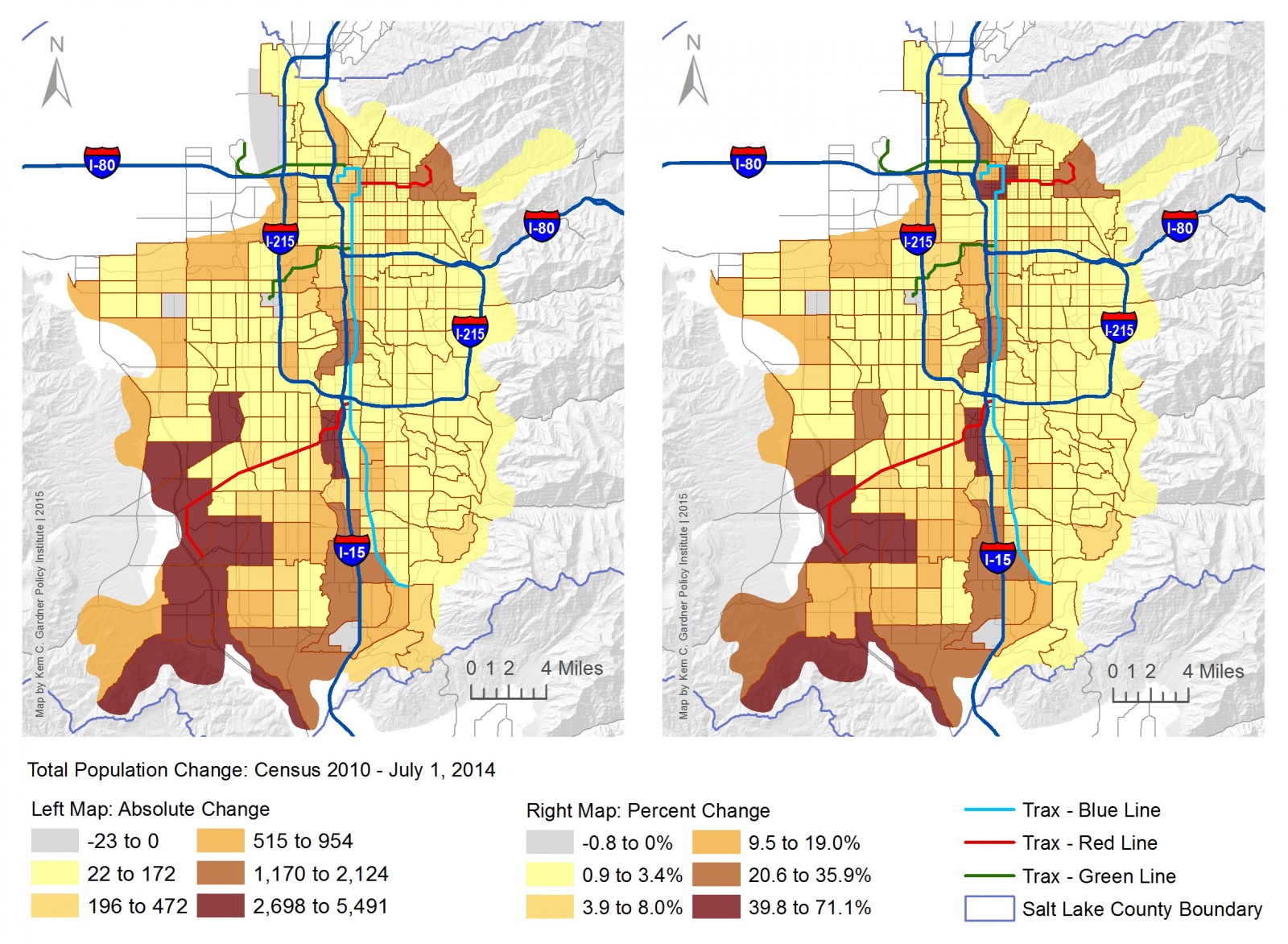
Today we release our tract level population, household, housing unit, and group quarters estimates for Salt Lake County. These are annual estimates for 2010 through 2014 for all 212 census tracts within Utah’s most populous county. Our analysis shows that areas of rapid growth are in the southern portion of the county (Bluffdale, Herriman, and South Jordan), central valley (Midvale and Murray), and Salt Lake City.
Population and household growth in southern Salt Lake County is embedded within a larger growth dynamic that extends into northern Utah County, an area that has been called “Silicon Slopes.” Beyond residential construction, this larger region is website adding commercial and industrial buildings with corresponding employment growth. Housing changes in southern Salt Lake County are mainly driven by construction of single family homes, although multifamily construction has also contributed.
Increases in the populations of Murray and Midvale were in tracts adjacent to I-15 where multifamily developments have been completed. Within Salt Lake City, our analysis identified growth in on-campus housing at the University of Utah and large multifamily development in the central city as the main sources of population increase.
In this work we have used a housing unit method, which infers changes in the population from changes in the number of housing units. Building permit and demolition data is combined with other survey data to estimate the additional dwelling units and their associated populations. This method does not incorporate other important demographic drivers of change such as births and deaths.
These estimates update similar data from the 2010 census, which was conducted at the depths of the Great Recession. As the economic recovery has subsequently advanced, data from the 2010 count has become increasingly obsolete. More current small area demographic estimates are foundational information for service, program, and infrastructure planning decisions. To our knowledge, these data are the only freely available tract level demographic estimates for Salt Lake County for years after 2010.
This work is part of our larger Demographic Decision Support work program that has been funded by the Utah State Legislature. The estimates will be used to inform infrastructure investment, education planning, and other public and private sector decisions. The Policy Institute will continue to build capacity and develop data so this demographic work can expand statewide.
These estimates are explained in our paper: Salt Lake County Small Area Estimates: 2010-2014.
We also provide a geographic visualization that allows users to explore and download the data.
Dr. Pamela S. Perlich is the director of demographic research at the Kem C. Gardner Policy Institute.


